General information about case study
The Montafon is located in Austria in the western Province of Vorarlberg at the border to Switzerland in the Montafon Valley, situated in an alpine landscape in the Eastern Alps (Figure 1). The MOTIVE case study sets focus on the largest forest holding in the Province of Vorarlberg, the Stand Montafon Forstfonds (SMF).
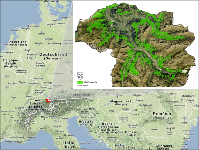
Figure1: Location of the Montafon case study. Small insert: green areas are forest property of the forest holding SMF (Stand Montafon Forstfonds).
The Montafon valley is part of the administrative district Bludenz. The size of the district is 187.52 km² and it is populated by 61,298 citizens (48 inhabitants/km²). The rugged alpine topography in the district of Bludenz limits settlements and pastures mainly to the valley floors (Figure 2). The regional economy depends on tourism (skiing in winter, hiking and mountaineering in summer), dairy farming on grasslands and mountain pastures, hydropower and forestry.
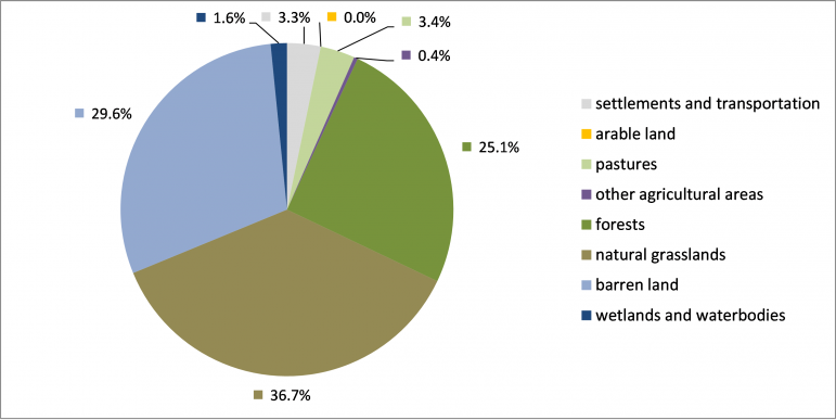
Figure 2: Land use statistics of the eight municipalities of the Montafon region (source: CORINE land cover EEA 2006).
The forest ownership in the district of Bludenz is dominated by small scale forest owners <200 ha which account for 42.9% of the forest area (Figure 3).
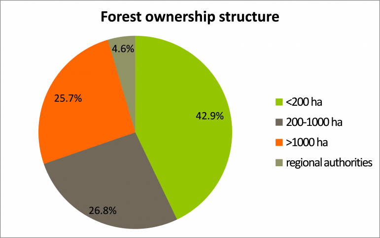
Figure 3: Forest ownership structure in the district of Bludenz (source: Austrian Forest Inventory).
Current climate, climate change scenarios and soils
The anticipated climate change features a distinct increase in temperature. The range of expected temperature increases in available regional climate change scenarios is 2.5 to 4.5 °C at the end of the 21st century. No major changes are expected for precipitation (Figure 5 and Figure 6).
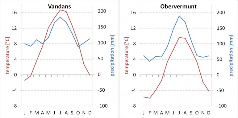
Figure 4: Climate characteristics of the weather station Vandans (670 m asl) in the valley bottom (left) and of the weather station Obervermunt (2040 m asl) at the timberline (right) for the period 1971-2000 (source: Central Institute for Meteorology and Geodynamics).
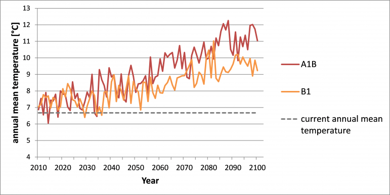
Figure 5: Expected temperature increase for the 21st century according to climate change scenarios A1B and B1 as provided within the MOTIVE project (based on CLM/ECHAM5 data, for more information please see Zimmermann 2010, and MOTIVE D2.2 Climate and land-use data).
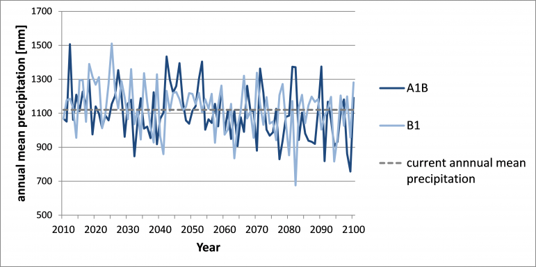
Figure 6: Expected precipitation changes for the 21st century according to climate change scenarios A1B and B1 as provided within the MOTIVE project (based on CLM/ECHAM5 data, for more information please see Zimmermann 2010, and MOTIVE D2.2 Climate and land-use data).
The Montafon features a steep altitudinal gradient from ca. 600 m at the valley entrance up to 3312 m at the summit of Mt. Piz Buin. The vegetation belts range from the submontane up to the nival zone. The actual timberline is located at approximately 1800 to 2000 m asl depending on the local climatic and edaphic conditions. The geology in the northernmost part of the Montafon is characterized by calcareous bedrock (limestone and dolomite) whereas in the larger southern part crystalline bedrocks (e.g. gneiss and amphibolite) dominate. On calcareous bedrock rendzinas, luvisols and cambisols are dominating. Ranker, podsols, semi-podsols and shallow cambisols are the most important soils on crystalline parent rock material.
Forests in the Montafon
The largest part of the forest is located on steep slopes which require skyline based logging techniques (Figure 9 and Figure 10).
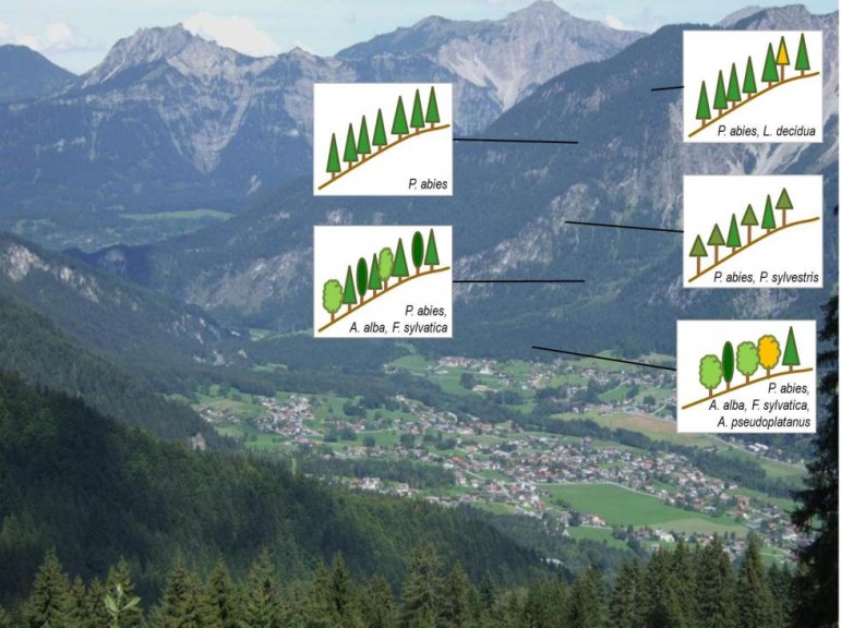
Figure 8: Major forest types in the Montafon case study along an altitudinal gradient.
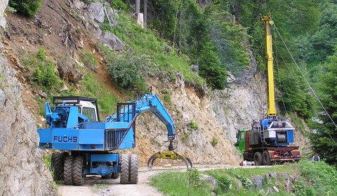
Figure 9: Management on the steep slopes is relying on skyline based logging techniques (photo: Stand Montafon Forstfonds).
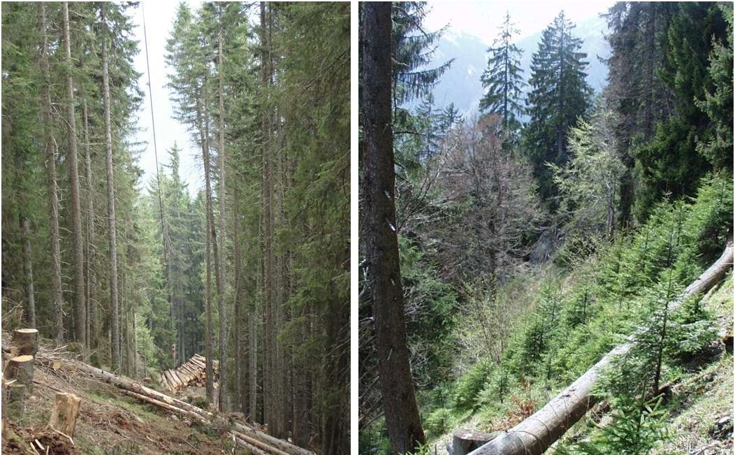
Figure 10: View along a skyline track at the time of harvesting (left) and 15 years after logging (right) (photo: Stand Montafon Forstfonds).
Stakeholder and demanded ecosystem services
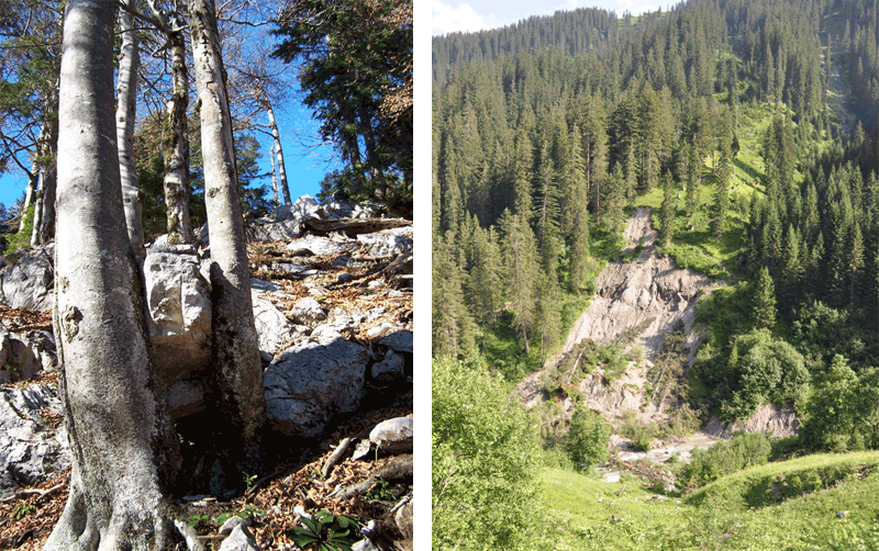
Figure 11: A limestone rock retained by beech trees (left, photo: Rupert Seidl). Landslide erosion of lateral moraines on forested slopes (right, photo: Manfred J Lexer).
Figure 12 displays the distribution of regional stakeholder preferences regarding a set of forest ecosystem services. In general the protection against gravitational natural hazards is of paramount importance to all stakeholders.
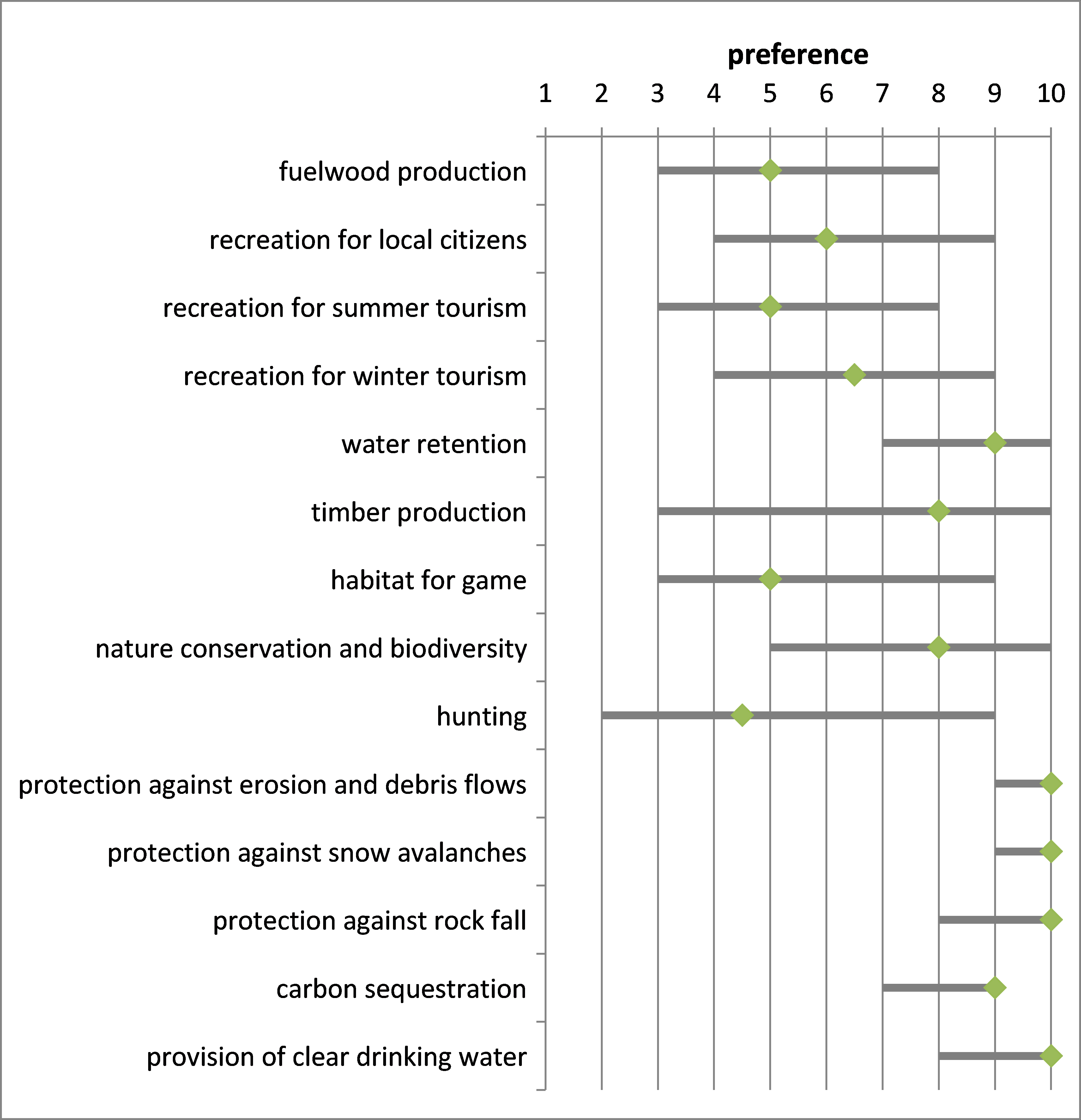
Figure 12: Importance of forest ecosystem goods and services (1=low relevance, 10=high relevance) in the Montafon. Grey bars represent the response of a panel of (n) different stakeholder representatives. Diamond symbols indicate the median, the grey lines indicate minimum and maximum values.
Stand Montafon governance
The Stand Montafon Forstfonds (SMF) is the largest forest holding in the Province of Vorarlberg. SMF is some kind of a community forest. There is a long tradition in public land-use in the Montafon region. The inhabitants of the valleys of the Montafon have had the chartered right to use the non-private forests in their valleys as a source for timber and fuelwood since the year 1601 AD. The ownership, however, was held by the state until the year 1832. In the year 1832 eight municipalities in the Montafon purchased approximately 8000 ha of forests from the state. Since then these municipalities have the unseparated ownership of this land and established the SMF for its management. The area owned by the SMF nowadays represents 8474 ha of which 6470ha are forests (Table 1, Figure 14).
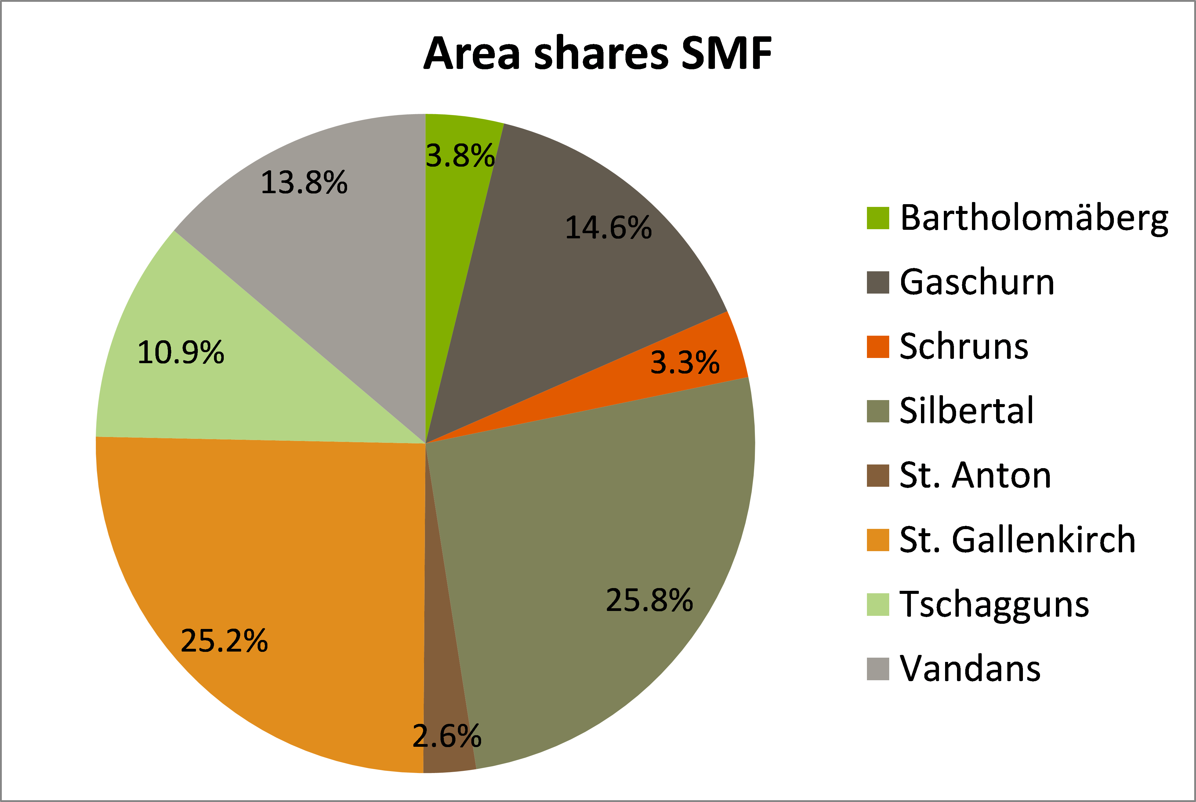
Figure 14: Area shares of the eight municipalities of the SMF.
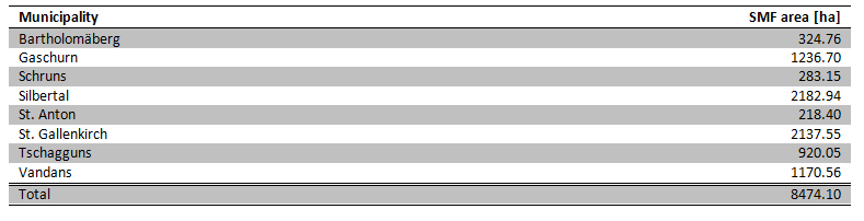
Table 1: Municipalities and their share of the SMF area.
The responsible body of the SMF is the board whose eight members are commissioned by the eight municipalities, one member for each municipality. All board members have equal voting rights. The chairman is elected by the boardfrom among its members. The operational management is run by a managing director who has to consult the chairman of the board in issues of fundamental relevance (e.g. acquisition or sale of land). Strategic decisions are made by the board. The SMF has seven permanent administrative employees and up to 15 lumbermen. Additional regional workforce is contracted based on demand. The returns from business operations are reinvested, in case of financial losses the municipalities are held liable.
The management objective of the SMF is the sustainable and economic use of the forest resources for all possible demands of society. Most notably this is the fulfillment of servitudes and the sustainable production of timber and the protection of the (cultural) habitat Montafon. The interests and demands of the citizens (internal stakeholders) of the Montafon are represented by the board of the SMF consisting of eight members (one member per municipality). There is no explicit participatory approach to consider the demands of external stakeholders. However, there are long-standing informal processes which grant the respect for stakeholder needs and interests.
The law-enforcement of the Austrian forest law is conducted by the forest administration at the district level. The management plans designed by the SMF are approved by the forest administration after an informal review process for periods of e.g. 10 years. There is no prescription of forest management by the authority. Typical for the Montafon region, the bigger part (82%) of the SMF forest area are forests with a dominating protective function. This is also reflected in the Forest Development Plan which is issued by the forest authority (cf. figure13). This forest land use plan serves as a basis to enable the SMF to apply for increased subsidies for forest management, due to the relevance of forest stands for the protection against natural gravitational hazards.
Will the risk profile of tree species change under climate change?
Due to warmer conditions Fagus sylvatica and Acer Pseudoplatanus as well as Fraxinus excelsior will be less affected by winter frost. However the future development of early and late frosts remains uncertain. Another important abiotic factor with large uncertainties with regard to the future development is the snowpack on the steep slopes of the Montafon which causes mortality in seedlings due to snow creeping and gliding. If future conditions feature more frequent wet snow precipitation events damages from snow breakage will increase. Wind throw is currently playing only a minor role in the disturbance regime. This is not expected to change in the future. Given the current and projected climatic conditions forest fires are not a concern in the case study region.
For Norway spruce there will be an increasing bark beetle infestation risk due to better development conditions for poikilothermal insects. Figure MO-1 shows simulated salvage from bark beetle infestations in a warmer climate for the Montafon. Especially during the second half of the 21st century a strong increase in bark beetle (Ips typographus) induced mortality can be expected for Norway spruce. For silver fir the bark beetle risk in the future remains uncertain. There has been less research on insects feeding on Silver fir compared to Norway spruce and the knowledge base is still limited. For ash future development is uncertain because of current severe dieback symptoms caused by the fungus Chalara fraxinea. Reduced precipitation and warmer temperatures may negatively affect conditions for Lachnellula willkommii (larch cancer) and thus improve the growing conditions for European larch.
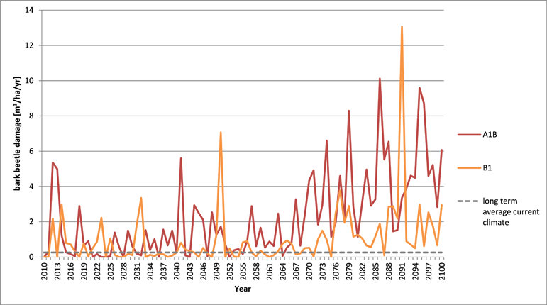
Figure MO-1: Simulated future bark beetle damages for two climate change scenarios under continuation of current management practices (BAU management) in relation to the long term average damage under current climatic conditions.
Are the tree species in the forest sensitive to climate change?
The assessment of tree species sensitivity to climatic changes in the case study distinguishes three key ecosystem processes (a) growth, (b) regeneration and (c) mortality of trees with regard to three time horizonts: (i) short-term (up to 2020), (ii) mid-term (2020 to 2050) and (iii) longterm (2050 to 2100).
Growth
All tree species in the region will actually physiologically benefit from a warmer climate because water supply on most sites is not a limiting factor (current precipitation levels exceed 1100mm/year and decreases in precipitation as expected for the future are of minor importance). Tree growth will increase because of more favorable growing conditions and longer growing seasons.
Regeneration
In the short run, similarly to the expected changes in growth, not severe changes are expected. Mid- to long-term the ecological conditions for regeneration will improve as periods with snow cover will become shorter and growing season length will increase. At intermediate altitudes between 800-1500m this will particularly favour the broadleaved species Fagus sylvatica and Acer pseudoplatanus which will be more competitive relative to Norway spruce.
Mortality
Due to warmer conditions Fagus sylvatica and Acer pseudoplatanus as well as Fraxinus excelsior will be less affected by winter frost. However the future development of early and late frosts remains uncertain. Another important abiotic factor with large uncertainties with regard to the future development is the snowpack on the steep slopes of the Montafon which causes mortality in seedlings due to snow creeping and gliding. If future conditions feature more frequent wet snow precipitation events damages from snow breakage will increase. Wind throw is currently playing only a minor role in the disturbance regime. This is not expected to change in the future. Given the current and projected climatic conditions forest fires are not a concern in the case study region.
For Norway spruce the risk of bark beetle infestations will increase substantially due to better development conditions for poikilothermal insects. Especially during the second half of the 21st century a strong increase in bark beetle (Ips typographus) induced mortality can be expected for Norway spruce. For silver fir the bark beetle risk in the future remains uncertain. There has been less research on insects feeding on Silver fir compared to Norway spruce and the knowledge is still limited. For Fraxinus exc. future development is uncertain because of current severe dieback symptoms caused by the fungus Chalara fraxinea. Reduced precipitation and warmer temperatures may negatively affect conditions for Lachnellula willkommii (larch cancer) and thus improve the growing conditions for European larch.
For a summary of the tree species sensitivities please see Table MO-1.
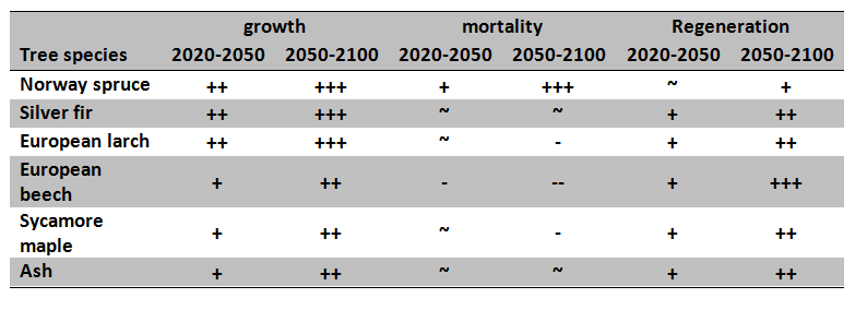
Table MO-1: Mid- to longterm tree species sensitivities towards projected climate change for the three forest ecosystem processes. (+ increase, ~ no change, – decrease)
Assume that current management (BAU) is continued: Is it possible to achieve current goals also under climate change conditions?
The formal overall goal of the forest holding SMF is the sustainable and profitable use of the forest resources for all possible demands of society. Operationally this includes the fulfillment of timber servitudes and the production of timber to create revenues, the maintenance of the protective services against gravitational hazards and the protection of the (cultural) habitat Montafon (biologically as well as socially).
Current management practices (business as usual; BAU) rely on long-distance cable yarding with skyline systems. The skyline tracks are set up diagonal along the slopes over distances of up to 1000m. Along the skyline tracks irregularly shaped slit and patch cuts are implemented in order to initiate and favour natural regeneration. Harvesting is done motor-manually, harvested trees are cut to length (4-6m logs) on site. The current management intensity (i.e. implemented skyline tracks per year) equals a virtual rotation length of 250 years (Figure MO-2).
In the short run (until the year 2020) a continuation of BAU management will not affect the planned provisioning of ecosystem services. However, due to the high share of Norway spruce in the forests of the Montafon timber production, as well as protection against gravitational hazards are likely to be negatively affected by intensified disturbance regimes, particularly from bark beetles. The long virtual rotation length and the focus on Norway spruce keep a high share of the forests in conditions of high susceptibility with regard to bark beetles. The need for salvage operations will increase in a warmer climate which in turn will negatively affect the planned harvest schedules and will subsequently increase the average harvesting costs per m3 timber. The intensified disturbance regime may also negatively impact on Carbon sequestration. However, due to a higher share of standing deadwood caused by bark beetle infestations the habitat and biodiversity functions for different vertebrate (e.g. woodpeckers) and invertebrate (e.g. longicorn beetles) species is expected to improve (Table MO-2).
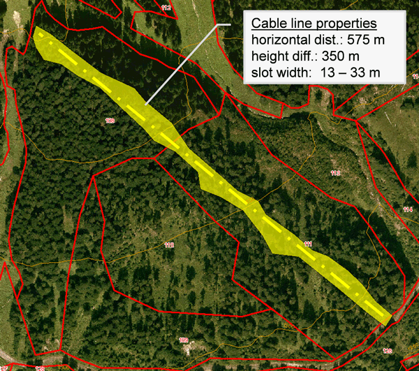
Figure MO-2: Current management practices rely on long distance cable yarding with skyline systems. The skyline tracks are widened with irregularly shaped slit and patch cuts (yellow).
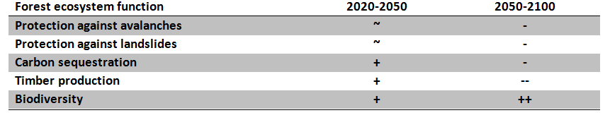
Table MO-2: Impacts of expected climate change on different forest ecosystem functions in the Montafon (+ positive impacts, – negative impacts, ~ indifferent).
Which adaptive measures appear as suitable response to the changing climate in order to sustain the provision of demanded ecosystem services? What is the recommendation to the forest manager?
There are several options available to adapt forest management in the Montafon to a changing climate. Based on the currently high share of Norway spruce broaden species composition towards a more diverse set of less vulnerable species will be a long-term objective. Silver fir, European larch and broadleaved species such as sycamore maple and European beech could be promoted as admixed species.
Silver fir is less favoured as timber species but performs at least as well as Norway spruce for protective functions. It may itself be subject to higher risk from bark beetle infestations in the future. Broadleaved species will positively affect biodiversity, but will not directly support timber production goals as these species in the current management frame will mainly produce low quality logs and fuelwood. For rockfall and avalanche protection broadleaves are considered less effective compared to winter green conifers.
European larch could be promoted as a valuable timber species, too, however due to its current absence in the Montafon the promotion of larch will rely on artificial regeneration. For the other species seed trees for natural regeneration should be available in sufficient abundance. However, any attempt to promote other species than Norway spruce will require improved game management approaches. The densities of ungulate game species such as roe deer (Capreolus capreolus), red deer (Cervus elaphus) and chamois (Rupicapra rupicapra) are currently at high levels causing severe browsing pressure on tree species susceptible to browsing (Silver fir, sycamore maple and European beech). This favors Norway spruce and is a strong limitation to any successful establishment of species mixture. The counter measures will have to include a reduction of the deer populations and changes in the hunting strategy towards intensified hunting where regeneration needs to take place and reduced disturbance by hunters and other nature users, like hikers or backcountry skiers. It is important to note that all actions aiming at changing the actual tree species composition will require significant time-lags.
Analysis has clearly shown that continuation of BAU results in increasing timber stocks which in turn increases susceptibility to bark beetle infestations and may also increase damage levels. Clumped tree mortality will in turn negatively affect the protection effect against gravitational hazards. As adaptive measure to mitigate these effects it is recommended to increase the annual cutting area by increasing the number of skyline tracks. At the same time the cutting pattern along the tracks should be modified. To keep gaps in slope direction as small as possible to prevent e.g. falling rocks from gaining too much speed a horizontal slit cut approach is recommended. Overall, this will reduce the cutting area per skyline but in combination with more skylines per year increase total annual cutting area (compare Figures MO-3 for BAU and Figure MO-4 for recommended management).
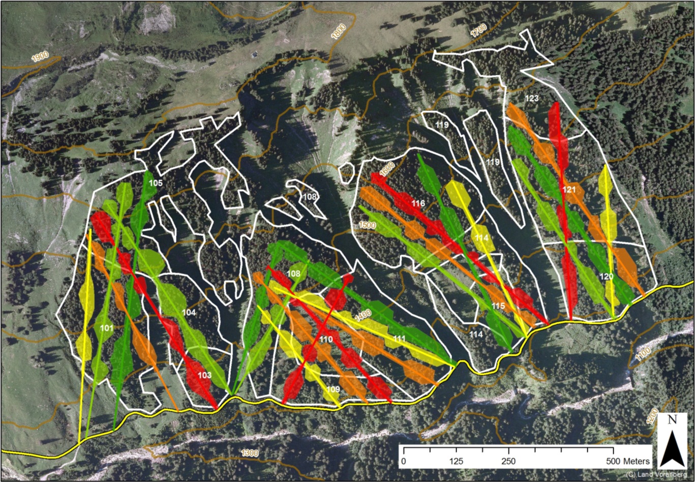
Figure MO-3: Slit and patch cuts as performed under current management as planned over 100 years for a forest compartment of ca. 70 ha. The colors of the slits cuts and skyline tracks indicate 20 year time periods from green to red (from 2010 to 2110). The stands are displayed in white and the road at the bottom of the slope in yellow. This approach results in a virtual rotation period of 250 years.
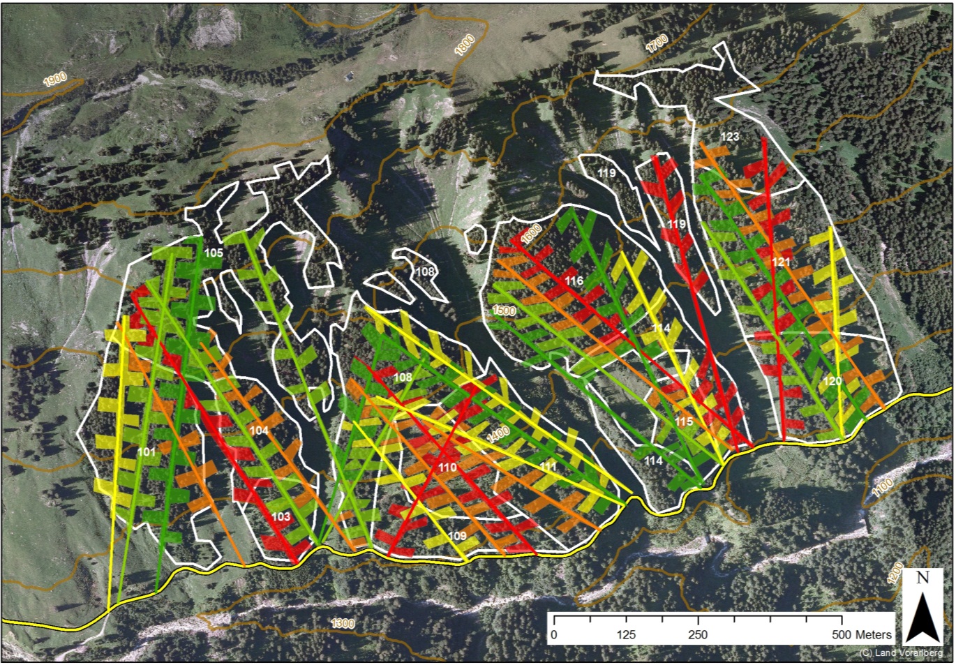
Figure MO-4: Fishbone shaped slit cuts as proposed as an adaptation measure planned over 100 years for a forest compartment of ca. 70 ha. The colors of the slits cuts and skyline tracks indicate 20 year time periods from green to red (from 2010 to 2110). The stands are displayed in white and the road at the bottom of the slope in yellow. This approach results in a faster turnover of tree generations by 20%.
In order to sustain the longterm provision of demanded ecosystem services under a changing climate it is recommended to combine all these adaptation measures (species composition, spatial structure of silvicultural measures and management intensity, game management) (Figure MO-5).
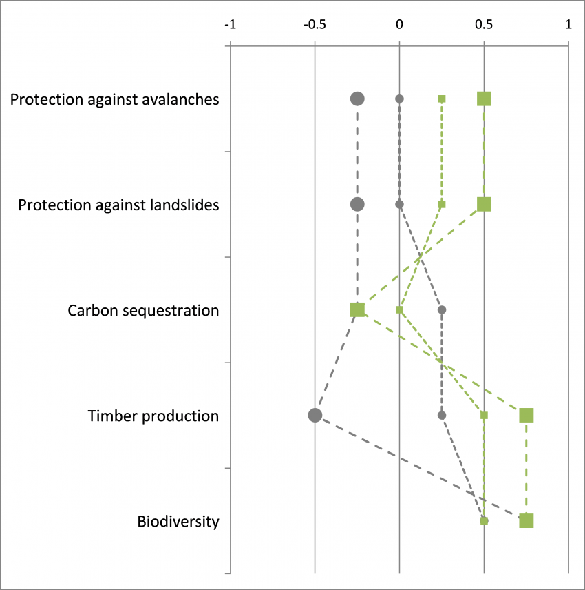
Figure MO-5: Qualitative performance profiles of current management (grey circles) and recommended management (green squares) under climate change. The smaller symbols represent the midterm period from 2020 to 2050, the large symbols represent the second half of the 21st century. Especially for the second half of the century strong differences between current and recommended adaptive management can be expected.
How did you come to your conclusion(s)? Which tools and methods did you employ?
A key pillar of the recommendations for the Montafon was a scenario approach where “What happens, if (…)” questions were answered. Once these key questions had been defined together with the SMF management team the scenarios to be simulated were set up accordingly. All management scenarios extended until the year 2100 to capture the signals of management as well as climate change. The dynamic forest ecosystem model PICUS v1.5 was employed for the scenario simulations. All together 5 management variants were simulated under 2 transient climate change scenarios and under current climatic conditions. A set of indicators representing the demanded ecosystem services (an example is given in the table below) was fed by model output and subsequently used to analyze the interrelationships of initial forest state, management concept including assumptions about game management intensity and climate conditions. Three time horizons were defined to better communicate the temporal implications of the scenarios (2020, 2050, 2100). To account for stakeholder preferences in evaluating the scenarios multi-criteria analysis techniques have been used.
| Indicator |
Unit |
Threshold minimal |
Threshold ideal |
Constraints |
| Gap size |
[m²] |
600 m² |
400 m² |
no regeneration, trees ≥ pole stage |
|
1200 m² |
800 m² |
with existing regeneration, trees ≥ pole stage |
||
| Crown cover |
[%] |
≥ 40 % |
≥ 60 % |
trees ≥ pole stage |
To better communicate the potential implications of scenarios to forest managers and stakeholders, landscape level visualization of forest development (Figure MO-6 and Figure MO-7), forest ecosystem service provisioning (Figure MO-8) have been used.
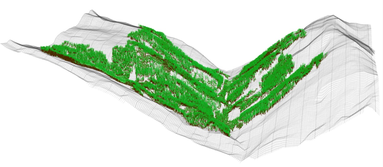
Figure MO-6: Landscape level visualization of 215 ha of forests embedded in a framework of non-stockable gullies and avalanche tracks in the Rellstal valley, Montafon. This small side valley features one south- (right) and one north-facing slope (left). They extend from 1160 m a.s.l. at the valley bottom to the actual timberline at around 1800 m a.s.l.
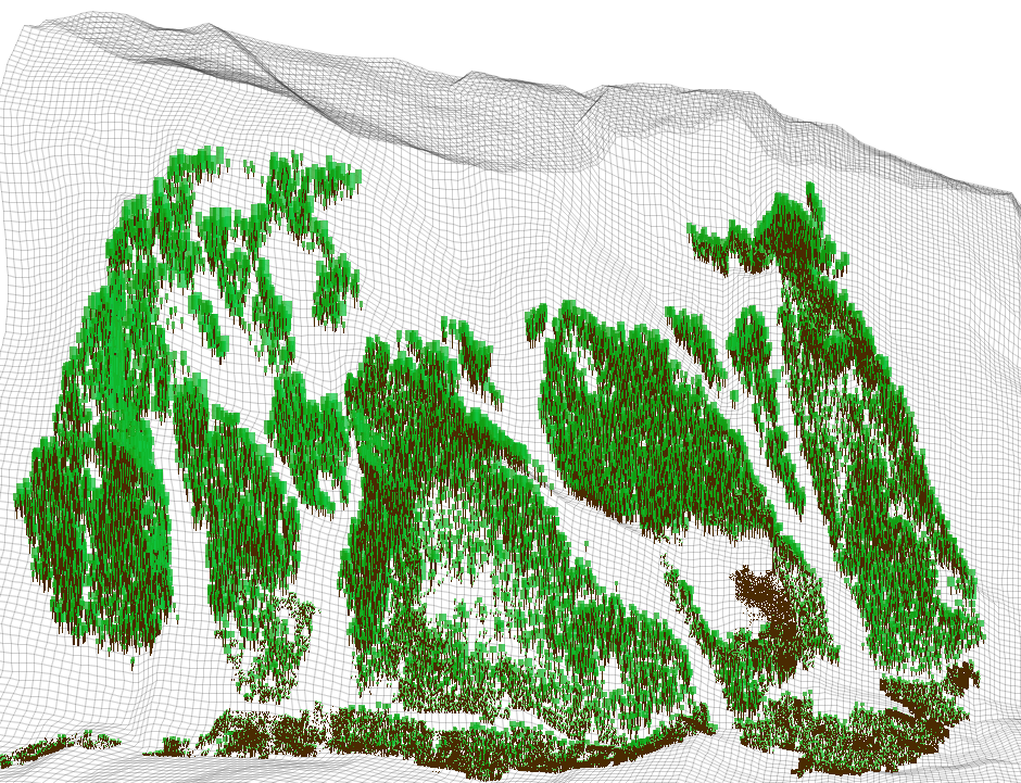
Figure MO-7: A more detailed visualization of ca. 70 ha forests of the south facing slope in the Rellstal valley in the Montafon. Meso-scale forest structure and distribution pattern is highlighted.
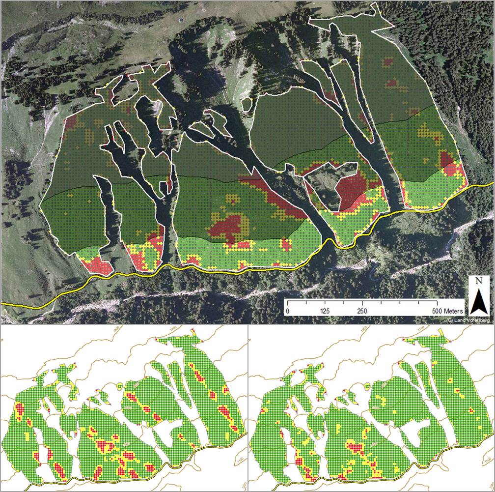
Figure MO-8: Visualization of the protection efficiency against landslides for the current forest conditions (year 2010, on top). The road (displayed at the bottom of the map; yellow line) is the object to be protected. The white lines delineate the analysis area. The results of the assessment are presented as colored pixels (a) green (optimal requirements met), (b) yellow (minimal requirements met) and (c) red (requirements not met). The shading of the map increases with distance from the road (300 m dark grey shading). Bottom left hand side: the protection against landslides for the current management under climate change in the year 2100 is shown. Bottom right hand side: results for the recommended management under climate change in the year 2100.
How do you incorporate uncertainties in your recommendations?
The general approach to handle uncertainties has been a cooperative decision with the local managers of the SMF. We decided not to feature a formal uncertainty analysis but we clearly try to separate different sources of uncertainty: climate change scenario uncertainty, knowledge gaps about tree species vulnerability, as well as uncertainty about the future disturbance regimes in communicating the results of the analysis to the stakeholders.
A scenario approach has been taken to derive recommendations for the Montafon case study. From a precautionary perspective the most severe climate change scenario available (story line A1B) has been used to derive the recommendations.
In estimating the future establishment success of silver fir, European larch or broadleaved species a conservative approach has been taken in the forest ecosystem simulations and in the interpretation of results. A certain level of browsing pressure on these tree species has been taken into account even in the management scenarios featuring a more intense game management.
Which obstacles are limiting the implementation of adaptive management?
Especially for the successful introduction of new species (European larch) and enhancement of silver fir and broadleaved species, as proposed as an adaptive measure, the browsing pressure is of paramount importance. In addition to that the introduction of new tree species via artificial regeneration in the steep terrain of the Montafon is laborious and costly. However at the moment it is unclear if the SMF, in cooperation with the hunters, will be able to reduce the browsing pressure to an acceptable level. The reason is that the hunting rights are let for rent. The majority (roughly 80%) of the lessees are non-locals which are paying a considerable rent for attractive hunting grounds (i.e. hunting districts with a high abundance of attractive game species like red deer or chamois). The rent for the hunting districts is a substantial source of income for the SMF. This leads to two problems with regard to the implementation of the adaptation measures. First reducing game populations will eventually reduce the value of the hunting districts and the SMF will create less income from rents. Secondly non-local hunters will not be able to execute the increased shooting plans, which means that the SFM has to find motivated local hunters which most probably will not be able and willing to pay as much as the non-locals. This means that for a successful implementation of the recommended management the organization of hunting in the case study needs to be changed dramatically.